Day Trippin': Our 13 Favorite Places to Safely Social Distance
We hope you enjoy and take advantage of this list we have carefully researched for you. Get to know your local history, get some exercise and fresh air. But PLEASE exercise caution and common sense when visiting. Check each location for current COVID-19 information, as it is constantly changing.
EDITORS NOTE: As ALWAYS, Deviation Diaries does NOT promote nor support trespassing or any other forms of illegal activity. ALWAYS seek permission before entering any property, and adhere to signs and regulations posted at each site. Have fun, and always put safety first!
The Deviation Diaries' way is to leave these places in better condition than you arrived!
Talitha's Recommendations:
Location: Located in a rural area of Central Stockton. Approximately 1 hour South of Sacramento. Take CA 99 S. Take the 260 exit off the Southbound 99 Highway. Turn right onto 99 N Turn left onto E. 8 Mile Road. These last turns are close together.
Hours of Operation: 24 hrs. However, the ghostly apparitions appear at night.
Brief History: The property along E. 8 Mile Road was once Native American land and burial grounds. This may be the reason for all the hauntings. Along with hauntings on the road, many residents have reported paranormal activity in their homes.
One ghost is a native American girl who suffered an accident
on one of the properties on 8 Mile Road.
It is said that she cursed the property’s owner and future tenants. She said that her ancestors will walk the
mile and will forever war and wail on the property. People living on the property have suffered
several accidents and paranormal events over the years. She enjoys screaming loudly at night
according to those who live in the area.
The second ghost is a Native American woman who is harmless
and does not bother anyone. She usually
appears along the road on nights with a full moon.
The most popular ghost is the lady in white. She has been seen the most by many along E. 8
Mile Road. The legend goes that if you
pass her and look in your rearview mirror to see if she is still there, you
will find her sitting in your back seat.
In addition, many drivers claim that they have gotten
confused, turned around or lost while driving this stretch of road and that their
GPS stops working.
Why it’s a favorite/personal opinion/experience: I was born in Stockton, CA. I have never been to E. 8 Mile Road, but I love a good ghost story.
Anything anyone should know before they go: The properties along this roadway are private properties. Please do not go onto private properties. Some ghost hunters have been arrested for trespassing on private property along this road. Please be considerate. Do not travel alone on this spooky road and engulf yourself with positive and strong thoughts. It is said that malevolent spirits target the weak and scared. You have been warned.
COVID-19 precautions, regulations: It’s recommended to continue using state-mandated precautions while visiting. Keep your distance from others and wear your mask and practice sanitary hygiene practices while traveling and when you must come in contact with others.
References and more info:
Backpackerverse.com, The terrors haunting East Mile Road


Photo by Joseph Coulombe – Memorial to all those who have died on rural roads.
★ Preston Castle (Preston School of Industry)
Located: 900 Palm Drive, Ione, CA 95640 The town of Ione is only about 45 minutes from both Sacramento and Stockton. The Castle’s tower is easily seen from several miles. Once in Ione, Preston Castle is at the end of Palm Drive, off of Highway 104.
Hours of operation: The hours of operation depend on what type of tour you want to take. There are many different types of tours available. However, many tours are only available on certain days of the week at certain hours. You should plan ahead. While restrictions due to COVID-19 may impact the ability to go inside, the town of Ione is a great place to check out. Ione has many historical locations including two local historic cemeteries.
Telephone:
1-209-256-3623
Email:
info@prestoncastle.org
Brief History: The Castle was built in 1894 as the administration building for the Preston School of Industry a reform school for boys from 1894 to 1960. It was built to rehabilitate, rather than simply imprisoning juvenile offenders. Prior to the school being built, the boys were housed, along with adult convicts, at San Quentin Prison. A housekeeper, Anna Corbin, was bludgeoned to death in the Castle in 1950. No one was ever convicted of the crime. However, because of this gruesome crime, a handful of unexplained deaths over the years, and a lost cemetery on the grounds, the site is said to be haunted and has been visited by almost every paranormal television program. In addition, many books have been written about The Castle. The Preston School of Industry is a California Historical Landmark and is listed on the National Register of Historic Places.
Why it’s a favorite/personal opinion/experience: I have never been to Preston Castle, but it is on my bucket list. My father worked as a cook at the Preston School of Industry in 1956. He did not stay long. As a cook, he worked daily with some of the boys. He said it was difficult for a number of reasons and did not want to continue working there.
Anything anyone should know before they go: All the tours involve stairs. Cameras are allowed but no tripods are allowed.
COVID-19 precautions, regulations: Tours of the inside of Preston Castle are currently unavailable through August 31, 2020. However, you can see The Castle from the outside, as it has a huge presence. Preston Castle Haunt begins October 10, 2020. Currently, this has not been canceled. This is a fun Haunt walk through the Castle and not a historical tour of the Castle. However, you must purchase tickets in advance. These tours will occur on most Fridays and Saturdays in October.
References and more info:
Preston Castle
Grey, Orrin, Preston Castle: The Haunted Reform SchoolYou Can Actually Visit


★ The Sacramento City Cemetery
Located: 1000 Broadway, Sacramento, CA. The main gate is at Broadway and 10th Street
Hours of operation: Mon-Sat - 8:00 AM - 5:00 PM. Sundays - closed
Brief History: The Sacramento City Cemetery is the oldest existing cemetery in Sacramento and one of the oldest in California. The cemetery was established in 1849 when John A. Sutter, Jr. donated 10 acres to the city. The cemetery has become the final resting place for over 25,000 people. The cemetery was built to resemble a Victorian garden. The cemetery contains many of the early legislature, governors, and other founding fathers of California. There is a mass grave of 600 victims from the Cholera epidemic in 1860. There are numerous military graves including a section of over 60 graves of Union Soldiers from the Civil War. The cemetery is well known for its flowers and historic rose gardens. Of course, being a graveyard, there are a number of ghost stories that are associated with the Old City Cemetery.
Why it’s a favorite/personal opinion/experience: I love anywhere history related.
Directions/location/coordinates: 1000 Broadway, Sacramento, CA.The main gate is at Broadway and 10th Street
Anything anyone should know before they go: Please follow the posted rules and general rules of the cemetery. Please show respect at all times. Do not touch any monuments or headstones. This is not only disrespectful but may cause damage as the stones may be incredibly old. Do not walk or stand on graves. Walk in-between headstones.
COVID-19 precautions, regulations: Due to Covid-19 tours are not available. However, everyone is encouraged to come to visit and tour the cemetery on their own. Please practice social distancing.
References and more info:


Photo by Camp22.org
 KCRA3
KCRA3 Photo by Patty Hankins


★ Glen Tavern Inn
Located: 134 N. Mill Street, Santa Paula, California 93060
Note: The Glen Tavern Inn is located in Santa Paula, California, in Ventura County right off the 126 highway. It is just 12 miles inland from the City of Ventura. The hotel is a short drive from the gorgeous Pacific Coast and Santa Paula Airport. It is one hour from Los Angeles and Santa Barbara.
Hours of operation: You can book a reservation 24/7 online or you can call the Inn during regular business hours. You can book by phone: 805-933-5550 • Fax: 805-933-5559 or by e-mail: kenneth@glentavern.com.
ALSO: A complimentary buffet breakfast is served on weekends from
8:00 AM to 10:00 AM.
The Inn has Enzo’s Italian Restaurant. Hours are: Tuesday - Thursday & Sunday - 5pm - 9pm | Friday & Saturday - 5pm - 10 pm
Brief History: The Glen Tavern Inn was built in 1911 when Santa Paula was a booming oil town. It has been beautifully restored to its grand historic character. Named a national landmark in 1981. The hotel's 3rd floor was once a gambling parlor and house of ill-repute. During Prohibition, a speakeasy was added on the third floor. In Hollywood's early heyday, the town was a favorite big studio filming location. Stars including John Wayne, Carol Lombard, Harry Houdini, and Steve McQueen stayed at the Glen Tavern Inn.
The Glen Tavern Inn has been featured on many paranormal
shows. Most of the ghost stories stem from the
prohibition era. One is a ghost named
Calvin. Calvin was a cowboy that was gambling on the third floor. He was caught
cheating at cards and received a bullet to the head in the dispute. Calvin’s room is 308. The second major haunting is that of a lady
of the night. The lore of Rose, the lady
of the night, is that she was beheaded
after servicing one of her clients. Her room is Room 307. You can call the Inn and ask to specifically
book room 307 or 308.
Why it’s a favorite/personal opinion/experience: I love old historical buildings, old Hollywood, and ghost stories.
Anything anyone should know before they go: There are no elevators. However, there are rooms available on the first floor for people with disabilities.
Most pets are allowed but there is a fee unless it is a
service dog.
COVID-19 precautions, regulations: According to their website: Social distancing measures are in place. The property, including commonly-touched surfaces, are cleaned with disinfectant. Guests are provided with free hand sanitizer. Bedsheets and towels are washed at a temperature of at least 60°C/140°F. A Contactless check-out is available.
References and more info:
Glentaverninn.com, Glen Tavern Inn


Amanda's Recommendations:
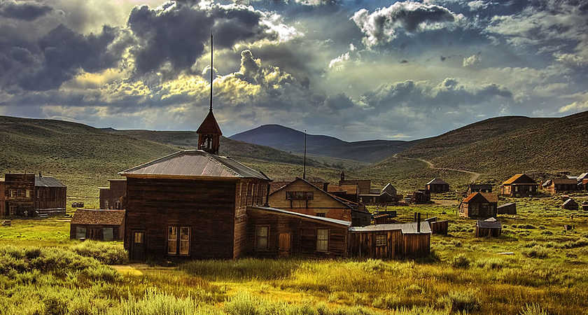
★ The "Ghostown" of Bodie
Located: CA-270, Bridgeport, CA 93517 - Driving Directions to Bodie SHP - The park is northeast of Yosemite, 13 miles east of Highway 395 on Bodie Road, seven miles south of Bridgeport.
Brief history: In its heyday, Bodie was mostly known for its lawlessness rather than the gold that was mined. In a diary of a young girl in San Francisco, it read " goodby god I'm going to Bodie". It is still not known if it was meant to say Goodbye, God I'm going to Bodie or Goodbye God, I'm going to Bodie.
In 1859 a miner named Waterman S Bodey discovered gold in the area now known as the Bodie Bluff. Unfortunately, Bodey died in a snowstorm that same year, and he never saw what would become of the town named after him. It's not known when the spelling changed, but it is believed to have been changed either due to an illiterate sign painter or so that people would pronounce it correctly.
In 1861 the town was home to only about 20 Miners. The first mine that was erected was Bunker Hill Mine. Later after a slow start and changing many hands it became the Standard Mining Company. By 1878 the town increased to 5,000 people. By 1879 just one year later the town was up to 10,000 people. The town hosted 2,000 buildings, 30 gold mines, 65 saloons, and many brothels, and opium dens. The town did have a school, newspaper, several churches, and several banks as well.
The town became more known for its red-light district and lawlessness. There were a few fires that took a toll on the town. That and gold being found in Tombstone, Butte, and Utah caused a decline in population. By 1910 there were only 698 people left in Bodie. And the first talk of a ghost town was in 1915. In 1943 only 3 people were left in Bodie. Many of the homes look like the families just got up grabbed what they could and left.
It is a true ghost town experience.
Favorite personal opinion /fact/ experience: On my visit there it was a sunny day. It was August so it was pretty hot. As we walked through the town looking in all the windows you could see what life was like. A cloud suddenly covered the church which we were approaching and rain fell down on us. We sought shelter in the church, well as much as you could enter. It was amazing!
What to know before you go: This is a state park. Bring plenty of food, water, and other supplies. It can get very hot, and sunscreen is recommended. There is no smoking allowed.
COVID-19 precautions, regulations: parks.ca.gov/FlattenTheCurve
"UPDATE (May 29, 2020) - As California State Parks begins working with locals on a phased and regionally-driven approach to increase access to state park units where compliance with state and local public health ordinances can be achieved, it is important for visitors to continue to practice physical distancing and avoid congregating with people outside their immediate household. Everyone has the responsibility to mitigate the spread of COVID-19."
For More Info:
https://en.m.wikipedia.org/wiki/Bodie,_California
https://www.bodie.com/
https://www.legendsofamerica.com/ca-bodie/

https://westernmininghistory.com/gallery-image/7002/38941/
Alex Browne
https://savingplaces.org/stories/preserving-decay-exploring-the-ghost-town-of-bodie-california#.XxT1mFNlAwA

Bodies map in the 1880s

The museum
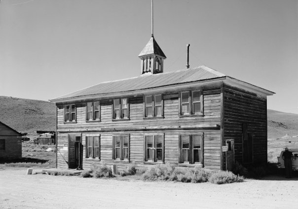
The school
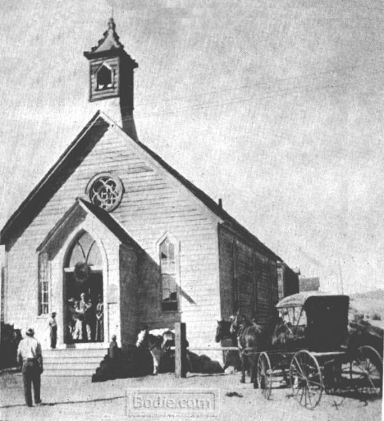
The church
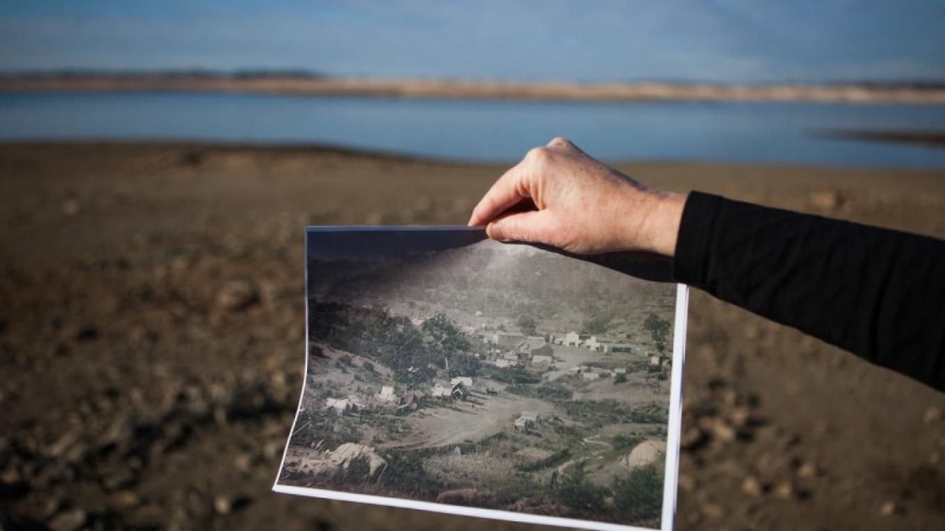
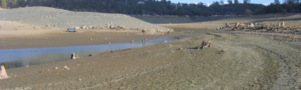
★ Mormon Island
Located: 1725 23rd Street, Suite 100, Sacramento, CA 95816
The marker is located at 38° 41.957′ N, 121° 7.654′ W
Hours of operation: 7:00 am to 5:00 pmBrief history: Mormon Island was built after 3 Mormon men hit the second-largest gold strike along the American River. In March of 1848 W. Sidney, S. Willis, and Wilford Hudson, members of the Mormon Battalion stumbled upon gold while stopping along the river. This was about 2 months after the discovery of gold in Coloma by James Marshall. After telling their story 150 Mormons and miners fled to the site and called it Mormon Island.
Other miners of the Mormon faith settled here and put up shops, and businesses. At one time it had 2500 residents, 4 Motels, 7 Saloons, and a School. In 1851 a post office was open in the town. One famous resident of Mormon Island and of Mormon faith was Samuel Brannon, who first publicized finding gold in San Francisco. He capitalized off of the miners. He then headed to Sacramento to do the same and became California's first Millionaire. Later he built Calistoga, lost all his money as and died poor.
In 1858 most of the town burned down. It was never rebuilt. By the 1950s the town had dropped to just a few residents and in 1955 when the Folsom damn was built Folsom Lake was created and the town was lost underwater.
In 2014 the town was once again exposed when the water levels were at the lowest in 37 years.
Favorite personal opinion/ fact/ experience: I loved exploring this town when it was exposed in 2014. I loved to learn of the history, and ties to the gold rush. Prior to that, I found it was peaceful to sit and look over the water and imagine the town in its heyday.
https://sierranevadageotourism.org/entries/mormon-island-no-569-california-historical-landmark/a40e9de0-9dfd-4f47-ab63-1b07d8c6e8a7
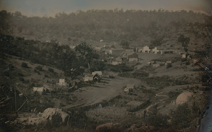


The town pictures from when it was booming.
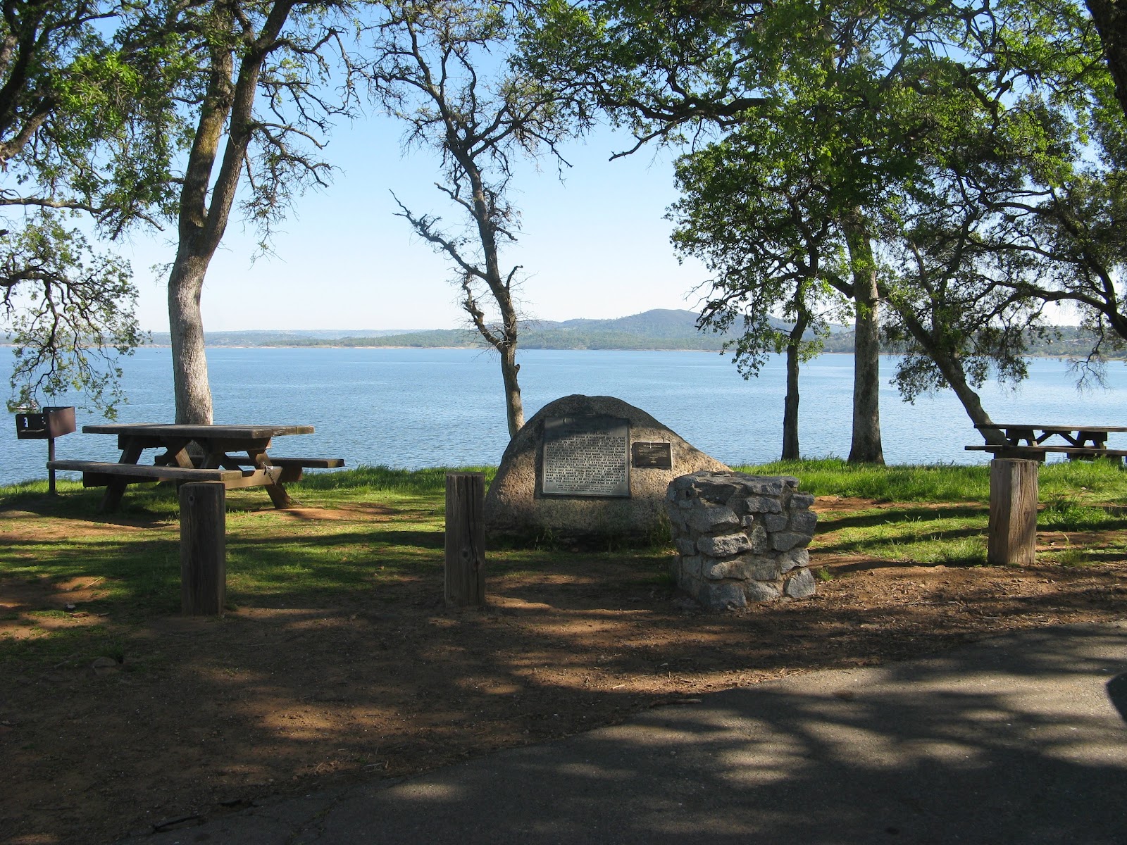
What Mormon Island looks like on a normal day.
The stream to cross to get to Mormon Island. The marina is in the back.
myfolsom.com

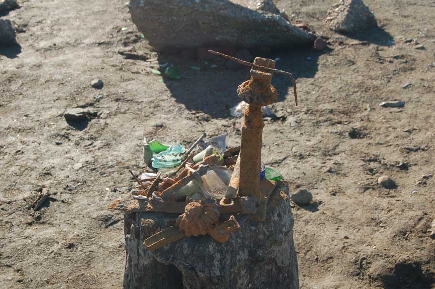

Photos of when the water level was low in January of 2014.
Before you go: there is a $12.00-day use fee at Folsom Lake
COVID-19 - precations regulations "State Parks continues to ask visitors to plan ahead, avoid road trips and stay close to home, maintain physical distancing, wear a face covering when a physical distance of six feet from others who are not from the immediate household members cannot be maintained, and avoid congregating. This means no gatherings, picnics, or parties. Visitors are being asked to leave if there are too many people to allow for the required physical distance. Full details on the guidelines are available at parks.ca.gov/FlattenTheCurve."
Additional Information:
https://www.atlasobscura.com/places/mormon-island
https://en.m.wikipedia.org/wiki/Mormon_Island,_California
https://sierranevadageotourism.org/entries/mormon-island-no-569-california-historical-landmark/a40e9de0-9dfd-4f47-ab63-1b07d8c6e8a7
https://ohp.parks.ca.gov/ListedResources/Detail/569
Anna's Recommendations:
★ Weimar Sanatorium Cemetery, Weimar, Ca
Hours of operation: Contact Colfax Cemetery District before making the trip to ensure you are within their business hours. 530-346-9577
Brief history: The 6 acre Weimar Cemetery was the
original cemetery for the Weimar Joint
Sanatorium was known for housing tuberculosis patients. Those who died at the Sanatorium and those were
considered destitute, Sanatorium property. As a Potter’s Field, graves have
been marked with 2x6 wooden grave markers with brass numbers. There is a
website online where you can compare the grave numbers to the numbers on the site
and find out who’s buried where. Since this was essentially a Potter's Field,
instead of traditional tombstones each grave was assigned a number which was
engraved onto a brass disc. The graves were marked by a piece of 2x6 wood with
the corresponding brass disc attached. Records in the Sanatorium office
translated names to numbers and vice-versa. The records also had information on
where the person lived before being admitted to the Sanatorium and other data. (http://genealogytrails.com/cal/placer/Cemeteries/weimarcem.html)
While many graves are marked, many are not, leaving many identities of the dead
unknown.
Why it's a favorite/ personal opinion/ experience: The
Weimar Cemetery is not your everyday cemetery. If you are looking for an
elaborate decorative cemetery, this is not the place for you. When approaching
the cemetery, you will believe that it is rather small, with wooden markers
leading you down a hillside. Once you follow the trails the magnitude of the
numbers of deaths at the Sanitorium over the years. It is quite the humbling
experience to be among so many forgotten. While driving through the old cemetery
grounds, you will jump back to the early 1910s as much of the grounds look the
same as they did when used as a Sanitorium.
Before you go: The Weimar Institute has changed owners over the years, and is currently under ownership by individuals who use is as a wellness center “Weimar Family Care”. Drive past all the main buildings and then keep to the left where it becomes residential (people have been welcoming and helpful and helping us get to the cemetery). Stay left until you hit the Weimar Institute. The cemetery is just beyond the institute. Once you walk to the fence line, you will see a small sign indicating you have found the cemetery.
COVID-19 precautions, regulations: It’s recommended to continue using state-mandated precautions while visiting. Keep your distance from others and wear your mask and practice sanitary hygiene practices while traveling and when you must come in contact with others.
http://genealogytrails.com/cal/placer/Cemeteries/weimarhistorybook.html#__RefHeading__4696_711422627
https://www.findagrave.com/cemetery/1982200/weimar-sanatorium-cemetery
https://witness2fashion.wordpress.com/tag/tuberculosis-treatment-1919-1920/


★ The Rocklin Pyramid “Joel Parker Whitney's Pyramid Tomb”
Located: Rocklin, Ca, this personal tomb is near the 11th green of the
Whitney Oaks Golf Course, just north of Monument Park.
38.825928°N
121.246666°
Hours of operation: There are no set hours for this site,
but park hours are recommended which are from
Brief history: Built around 1880-1910, in the
strangest of places, Joel Parker Whitney’s tomb is located near the 11th green
of the Whitney Oaks Golf Course. In January 1913, Joel Parker Whitney, known
Parker at the time passed away from kidney disease. The 15 foot tall and 40
foot in diameter pyramid mausoleum was built by Parker, using native granite which
he had built for his family and himself. According to Rosevilletoday.com
“The pyramid shape probably resulted from Whitney’s believe (belief) in
Pyramidology, the belief that pyramids hold magical powers, including the power
to bestow reincarnation.” Today the tomb is a well-known stop for those who
love road trips for the unusual or off-beat. The tomb is located on Parker’s
old Spring Valley Ranch. According to Gold
Country Media, “Whitney family members set aside the acre for their
permanent use while they gradually sold off Spring Valley Ranch land to other
ranchers and land developers during the early to the mid-20th century.”
Since Parker’s interment, 23 other descendants and forefathers have been buried
in the tomb as well.
Why it's a favorite/ personal opinion/ experience: The tomb
is fascinating to see up close. There is an iron fence around the tomb site. A gate is there but unlocked during daylight hours. This is an easy flat hike through Rocklin's majestic oaks. If you examine the boulders
surrounding the tomb, you will find bedrock mortars where Nisenan Natives
ground acorns into mush until the early 19th century.
Before you go: This tomb is still visited by the family, so please show respect when visiting. Watch for poison oak! This is not an easy find upon entering the park. We asked locals who were happy to help. You can find the tomb from two approaches. The first if from the paved walking path of Rocklin Monument Park that begins in the cul-de-sac of Ketchikan Drive, and the second is from a footpath starting near the end of Hood Road and Sitka Drive in Rocklin, California.”
COVID-19 precautions, regulations: It’s recommended to continue using state-mandated precautions while visiting. Keep your distance from others and wear your mask and practice sanitary hygiene practices while traveling and when you must come in contact with others.
For more info :
https://www.rosevilletoday.com/travel/rocklin-history-tour-pyramid-tomb/
https://goldcountrymedia.com/news/2442/a-pyramid-for-a-tomb/
https://www.findagrave.com/memorial/75238800/joel-parker-whitney


★ The Necropolis of Colma
Located: Just south of San Francisco.
Hours of operation: Each cemetery located in Colma, have their own sets of rules and hours for visitation.
Brief history: From Wikipedia: “With most of Colma's land dedicated to cemeteries, the population of the dead—about 1.5 million, as of 2006—outnumbers that of the living by a ratio of nearly a thousand to one. This has led to Colma's being called "the City of the Silent" and has given rise to a humorous motto, now recorded on the city's website: "It's great to be alive in Colma" Colma is a living breathing Necropolis has intrigued people for many years. With the surge of population, in 1900 San Francisco outlawed new interments within city limits and in 1912 graves within city limits were relocated to Colma, a city designated to the bay area’s deceased. Between 1920 and 1941, over 150,000 bodies were relocated at a cost of $10/ piece. Those that could not pay, or had no one to claim them, were dumped into mass graves and the tombstones were integrated into public works projects like sidewalks and gutters. Famously you can find some of these tombstones in the gutters of Buena Vista Park.Why it's a favorite/ personal opinion/ experience: My favorite things about Colma is seeing the unusual headstones from relocation sitting back to back with one another as if people are buried on top of one another and the beautiful stain glass of the mausoleums of Cypress Lawn. There are more than 1 CLs in Colma, this one is located at 1370 El Camino Real Colma, CA 94014. Call ahead for mausoleum hours and restrictions (650) 755-0580)
As a person who loves old Hollywood and finding famous graves, Colma is a MUST SEE. My personal favorites include (from Wikipedia):
Cypress Lawn Memorial Park
-Charles De Young, San Francisco Chronicle founder
-Phineas Gage, famous 19th-century medical curiosity.
-William Randolph Hearst, newspaper tycoon
-….and many, many more.
Hills of Eternity and Home of Peace (side-by-side Jewish cemeteries)
-Wyatt Earp is buried next to his wife, Josephine Marcus Earp
-Levi Strauss, denim trouser pioneer
Holy Cross Cemetery
-Joe DiMaggio, Yankees center fielder
-Abigail Folger, a coffee heiress, and Manson murder victim. (Located in Mausoleum)
Woodlawn Cemetery
-Joshua Abraham "Emperor" Norton, a late-1800s San Francisco celebrity known as "Emperor of these United States and Protector of Mexico"
-José Sarria, LGBT political activist who styled himself "The Widow Norton" in reference to Norton
Eternal Home Cemetery (Jewish cemetery)
-Bill Graham, music promoter
Greenlawn Memorial Cemetery
-James Rolph, San Francisco mayor and 27th governor of California
-Tina Turner's dog is buried somewhere in this small peculiar cemetery. I have yet to find 'em.
PRO-TIP: For getting the most out of your day, I recommend driving through the entire individual cemeteries and have a list of must-see's ready to pursue. Driving around the cemeteries instead of walking will save your energy and you'll get the most of your trip. Don't try to see it all in one day, it's impossible!
COVID-19 precautions, regulations: It’s recommended to continue using state-mandated precautions while visiting. Keep your distance from others and wear your mask and practice sanitary hygiene practices while traveling and when you must come in contact with others.
For more info:
https://thebolditalic.com/the-gutters-in-buena-vista-park-are-made-out-of-old-headstones-the-bold-italic-san-francisco-e6b1c7519d2b?gi=2bdefa1961d4
https://www.ranker.com/list/famous-people-buried-in-holy-cross-cemetery-colma/reference


Christopher's Recommendations:
★ Cherokee Cemetery
Located: 3297 Cherokee Rd, Oroville Ca 95965
Hours of operation: 8am to Dusk
Brief history: This private cemetery was established in the early 1850s around the pioneer town of Cherokee. The town was founded by welsh miners who named it after the already present Cherokee Indians who were panning for gold along the river. The story of the town covers everything from a visit by the President of the United States, Thomas Edison and Hydraulic Mining.
Why it's a favorite/ personal opinion/ experience: This amazing little cemetery has both the appeal of an out of the way mountain retreat and the magestic grace of nature and its calming effect on the whole site. On our visit to the cemetery I discovered it to be full of amazing headstones and some of the prettiest butterflies you will ever find. My personnel connection to the cemetery is the story of the death of the town's sweetheart Susan Mcdanel who was brutally murdered in 1871.
Additional Information: https://thedeviationdiaries.blogspot.com/2020/04/a-tragic-murder-in-cherokee-ca.html. This story is one of many of the stories that belong to the people buried here, please enjoy and discover a story of your own.
Before you go: Make sure you take plenty of water and wear good walking shoes.
COVID-19 precautions, regulations: Please Follow all state and local mandates in regards to social distancing and facial covering and enjoy this amazing pioneer cemetery. https://www.findagrave.com/cemetery/1967787/cherokee-cemetery


Located: State Route 45 Between Buster and Earp Roads
Hours of operation: Sunrise to Sunset
Brief history: Site of the first Catholic mass to be said in Colusa County, May 1856. In 1864, a Catholic mission was conducted and a large wooden cross erected to commemorate the occasion. Masses, pilgrimages, and visits were made here continuously thereafter. In order to preserve the identity of the place, Father Michael Wallrath secured a deed from Mrs. Anna Myers to this parcel of land and constructed a small shrine from hand kilned bricks in 1883. State of California Point of Historical Interest No. COL-001
Why it's a favorite/ personal opinion/ experience: This was such a fun site to visit because it takes you back in time to a meeting place of the Community. You can feel positive energy there and when you look inside the shrine it gives you a sense of reverence and puts you at peace. This site is what makes backroad exploration so much fun. You learn about the community and its people through places like this. It is a true example of finding a neat place alongside the road and opening a neatly wrapped piece of history to explore.
Additional Information:
https://noehill.com/colusa/nat1974000508.asp
COVID-19 precautions, regulations: Please follow all local and state mandates on social Distancing and face coverings


Located: 10433 Willow Valley Rd, Nevada City, CA 95959-2347
Hours of operation: Sunrise to Sunset
Before you go - Note: Please be respectful of this site, it has been abandoned, but it has suffered vandalism, graffiti, and just general abuse. Heed ALL TRESPASSING SIGNS. We have visited and trespassing signs indicate that night visits are FORBIDDEN, but day time visitors are welcome.
Brief history: This story in the Grass Valley Union tied to a tragic event that affected the whole Community: "Two separate gunfire attacks by a mental patient Wednesday left three people dead, three injured, authorities said, and western Nevada County trying to grasp a tragedy that previously seemed possible anywhere but here.
A daylong search for the suspect, Scott Harlan Thorpe, 40, a County Behavioral Health Department client, ended with his 9 p.m. arrest at his Smartsville house at 10743 Mooney Flat Road, the Sheriff’s Department reported."
Why it's a favorite/ personal opinion/ experience: The former County Hospital at this location has a deep history and the topic of Hospitals and Mental Care facilities can have some very dark and troubling stories. That being said, the tragic events connected to the HEW facility located here and the tragic deaths both at the facility and in Grass Valley is troubling because I knew one of the victims on a professional level. The manager on duty at the Lyons restaurant was some I knew. So as you visit this site I hope you will take in the whole range of emotions that you experience at this location.
Additional Information:
a great explanation about the History of this Site
Another great article about this site
COVID-19 precautions, regulations: Please follow local and state mandates on social Distancing and facial covering and be safe.


★ Grand Island Cemetery
Located: 2014 Dry Slough Rd, Grimes, CA 95950
Hours of operation: Sunrise to sunset
Brief history: Grand Island Cemetery was created in 1866 for the little city of Grand Island which is now known as Grimes.
Why it's a favorite/ personal opinion/ experience: This is another example of a small-town cemetery that brings us so many individual stories that create the fabric of small-town America. As you stroll through the grounds you will find this name Cleaton Grimes and the story of how he changed his community.
Additional Information:
Grand Island Cemetery Findagrave
A History of Grand Island and The Transition to Becoming Grimes
COVID-19 precautions, regulations: Please follow all local and State mandates on Social Distancing and Facial Coverings


Halo,I'm Helena Julio from Ecuador,I want to talk good about Mr Benjamin on this topic. gives me financial support when all bank in my city turned down my request to grant me a loan of 500,000.00 USD, I tried all i could to get a loan from my banks here in Ecuador but they all turned me down because my credit was low but with god grace I came to know about Mr Benjamin so I decided to give a try to apply for the loan. with God willing they grant me loan of 500,000.00 USD the loan request that my banks here in Ecuador has turned me down for, it was really awesome doing business with them and my business is going well now. Email/WhatsApp Contact if you wish to apply loan from them. Lfdsloans@outlook.comWhatsApp Contact:+1-989-394-3740.
ReplyDeleteNice post! Thank you so much for sharing this post with us. I really like to read it.
ReplyDeleteIndian Visa Online Application